


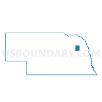
Butterfly Precinct, Stanton County, Nebraska
About
Outline

Summary
| Unique Area Identifier | 613968 |
| Name | Butterfly Precinct |
| County | Stanton County |
| State | Nebraska |
| Area (square miles) | 35.82 |
| Land Area (square miles) | 35.76 |
| Water Area (square miles) | 0.06 |
| % of Land Area | 99.84 |
| % of Water Area | 0.16 |
| Latitude of the Internal Point | 41.87757330 |
| Longtitude of the Internal Point | -97.20110610 |
Maps


Graphs
Select a template below for downloading or customizing gragh for Butterfly Precinct, Stanton County, Nebraska


Neighbors
Neighoring Voting District (by Name) Neighboring Voting District on the Map
- Dimick Precinct, Stanton County, NE
- Elkhorn Precinct, Stanton County, NE
- Haymow Precinct, Stanton County, NE
- Kingsburg Precinct, Stanton County, NE
- Maple Creek Precinct, Stanton County, NE
- Ramshorn Precinct, Stanton County, NE
- Stanton A Precinct, Stanton County, NE
- Stanton B Precinct, Stanton County, NE
- Union Creek Precinct, Stanton County, NE
Top 10 Neighboring County Subdivision (by Population) Neighboring County Subdivision on the Map
- Elkhorn precinct, Stanton County, NE (224)
- Stanton precinct, Stanton County, NE (208)
- Ramshorn precinct, Stanton County, NE (152)
- Maple Creek precinct, Stanton County, NE (151)
- Haymow precinct, Stanton County, NE (137)
- Butterfly precinct, Stanton County, NE (128)
- Dimick precinct, Stanton County, NE (115)
- Kingsburg precinct, Stanton County, NE (114)
- Union Creek precinct, Stanton County, NE (113)
Top 10 Neighboring Unified School District (by Population) Neighboring Unified School District on the Map
- Stanton Community Schools, NE (2,455)
- Clarkson Public Schools, NE (1,297)
- Leigh Community Schools, NE (1,077)